Clean Air PrimerContact UsSan Joaquin Valley Air Pollution Control District
OverviewScienceIssuesHealthSolutionsActivities
How Geography Affects Air Flow & Transports Pollution
N early every afternoon, winds from the ocean breezes push pollution against the coastal ranges north and east of the South Coast Air Basin and through mountain passes further inland and up against the San Gabriel, San Bernadino and San Jacinto Mountains. The streams of air carrying emissions mix with locally generated pollution from automobile traffic, small engine exhaust, industry, and agriculture and are diverted both north and south.
The Valley's geography is like a giant bathtub
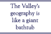
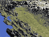
The South Coast Air Basin's geography is like that of a giant bathtub surrounded by mountains -- with a lid on top in the form of inverted layers of cool and warm air that cannot mix. This inversion layer traps both local and transported dirty air, sometimes for weeks or even months. Organized wind patterns in the summer help create an eddy or swirl-like pattern that circulates around the "tub."

Winds move inland in the daytime, transporting pollution toward Riverside and San Bernadino counties. At night, the process 
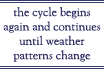
reverses, taking it back towards the ocean. The next day, the cycle begins again and continues until weather patterns change. This collection of trapped pollutants pushes against slopes on a daily basis-bringing some of the worst air quality in the nation to the second most populated area in the United States.
The cycle begins again and continues until weather patterns change
The typical wind flow pattern fluctuates only with occasional winter storms, or strong Santa Ana winds from the mountains and deserts northeast of the air basin. The Santa Ana winds blow polluted air out over the ocean. In the winter, the winds are slower and don't blow in a prevailing direction so there is no eddy pattern. But because of the low angle of the sun, inversions hang around even longer trapping pollution until the weather changes.

Next Next - The largest emitters of air pollution...

View of Central Valley

Click to See More about Air Flow & Geography

Human Eye

Eye-opening Fact...
Because of unique topography, a large population and nearly one car per person, California still has eight of the 10 smoggiest cities in the U.S.

Overview

  Air Transport Corridors

  Pollution Sources

  Criteria Pollutants

  Meteorology

  Visibility

  Acid Rain/Snow

  Air Pollution Advisories
 

© 2006 SJVAPCD. All Rights Reserved.